If we look at California as a whole, it is clearly not
a unified entity. There are a number of mountain ranges, a great central
valley, and large desert areas. Yet one factor that tends to unify most (though
not all) of California is its Mediterranean climate. A biological zone known as
the California Floristic Province covers the non-desert portion of the state
and is responsible for an impressive level of biodiversity, especially in terms
of plants. The California Floristic Province contains more plant species than central and northeastern U.S. and Canada combined.
About 47% of the flora of the California Florisitic Province is endemic (see
CA floristic province" by NoahElhardt - Own work. Licensed under CC BY-SA 3.0 via Wikimedia Commons - https://commons.wikimedia.org/wiki/File:CA_floristic_province.png#/media/File:CA_floristic_province.png
Along
much of the coast of California, the coastline is paralleled by a series of
mountains known as the Coast Ranges. These mountains, which run generally
north-south, are more than foothills, yet not as high as the Sierras. For much
of California, the Coast Ranges lie very close to the sea, as seen most
dramatically at Big Sur. Their influence on the flora of California is
significant. Where the Coast Ranges are dominant, they capture rainstorms
coming down from the north, causing them to unload much of their precipitation
onto their chaparral-covered slopes. Their relative lack of flat lands,
especially close to the coast, has also affected agricultural and urban and
development of this region, keeping the central and northern coast relatively more wild and less urbanized.

The San Andreas Fault System,California, ROBERT E. WALLACE, Editor
U.S. GEOLOGICAL SURVEY PROFESSIONAL PAPER 1515
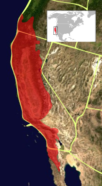
Something
very interesting happens right around Pt. Conception that begins to give
southern California vegetation a distinctly different flavor from its cousins
to the north. Near Pt. Conception the Coast Ranges peter out and are replaced
by the Transverse Ranges which run east-west. Further south, the Peninsular
Ranges resume a north-south line, but much further inland than the Coast
Ranges. Complex factors are responsible for this change in geography, including
sea level changes over millenia, erosion and deposition over millenia, and the
substantial impact of the San Andreas Fault system. The net effect of these factors
is to open up a broad swath of low elevation land between the coast and the
mountains, as shown in the above map.
The
land is question includes what is now the counties of Ventura, Los Angeles,
Orange and San Diego, along with the western-most portions of Riverside and San
Bernardino Counties. The elevations here are typically under 600 m, and the
slope is typically gentle from the seashore up to the foothills. While this
topography is certainly not flat and there is much variation at the local
level, the overall effect is to allow the marine influence to penetrate very
far inland, that distance depending on the precise alignment of canyons and
valleys. For example, in Ventura County, the Santa Clara River Valley runs inland
for approximately 45 miles to Castaic Junction where the elevation is still
only 310 m.
Weather
also takes a turn at Pt. Conception. Many winter storms, following the high
altitude jet stream, are turned eastward at or before Pt. Conception. The
Transverse Ranges play a role in this as well. Of course, some storms do make
it further south to deliver rain to southern California, but a quick glance at
a map of average annual precipitation shows that there is a definite dropoff in
rain south of Santa Barbara County.
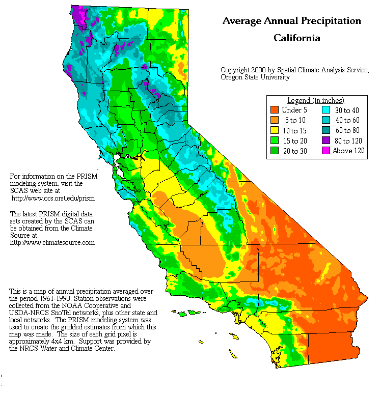
Looking
at the yellow areas of southern California on the map above, indicating rainfall
of 10-15 inches per year, this region of reduced rainfall very closely matches
the area of low elevation lands near between the coast and the mountains. In
discussing weather, we must also note that the Pacific Ocean along the coast of
California is generally cool in temperature because the predominant flow is coming
from the colder waters of the north. The currents are complicated and there are
many counter-currents and other factors, but the net effect is that the ocean exerts
a cooling effect on the climate near the coast, that effect diminishing
gradually with distance from the sea. This is just a normal part of the
Mediterranean climate dynamic.
Put
together a combination of low elevations and gentle topography, plus proximity
to the coast and marine influence extending far inland, plus reduced rainfall
relative to more northerly California and what do you get? An environment that
supports a very unique vegetation with lots of unique species. This assemblage
of plants, known as Coastal Sage Scrub, is even more highly drought adapted,
high in diversity, and extremely valuable for wildlife. And somewhat
surprisingly, the floristic diversity continues to increase as one goes from
north to south, toward the most arid part of this region, San Diego.
Coastal sage scrub is perhaps best understood by comparison with the better known chaparral. Although there are a few plant species that are found in both, there are distinct differences between them. In
a very general sense, slopes facing north or east tend to be more shaded and
thus somewhat better able to retain moisture through the long summer drought.
As a result, these areas generally (though not always) support a chaparral
vegetation that is evergreen, relatively tall ( up to 12 ft.) and dense. These
features, as well as mulch from leaf drop, contribute to the moisture-holding
capacity of the soil. This
relationship of chaparral to slope aspect is different in southern California
than in northern or montane California. In the latter two regions, woodlands
are found on north facing slopes and chaparral is found on the sunnier, drier
south facing slopes (see Introduction to California Plant Life; Ornduff, Faber
and Keeler-Wolf, 2003).
Conversely,
slopes facing south and west tend to be warmer and drier, less able to defend
against evaporation. This is where we would find Coastal Sage Scrub, consisting
of lower growing plants (3-6 ft.) that are less densely spaced, and often deciduous in summer. Much
of southern California was formerly covered with this type of vegetation, and
it is extraordinarily important for wildlife. Coastal sage scrub and chaparral are
not mutually exclusive and often grow together in a mosaic or patchwork manner,
sometimes including open areas of native grasses. Interspersed among the woody
and semi-woody shrubs we would find a large variety of herbs, annuals and
geophytes. These contribute significantly to the overall floristic diversity.
Some of the typical species of coastal sage scrub include Artemisia californica, Encelia californica, Eriogonum californicum, Yucca shidigera and Yucca whipplei, various Dudleya species, several cactus species, and many more. Geophytes (bulbs and corms) include members of the genera Calochortus, (Mariposa lilies), Dichelostemma, Brodiaea, and Chlorogalum. Annuals include Eschscholzia californica (California poppies), Castilleja exserta (Owl's clover), various Clarkia species, Collinsia heterophylla (Chinese Houses), various Gilia species, Layia platyglossa (Tidy Tips), various Lupinus species......I could go on and on. In fact, Calflora lists 944 native annuals in San Diego County below 600 m elevation.
 |
| Yucca shidigera, Eriogonum fasciculatum and Dudleya lanceolata in Encinitas |
 |
| Calochortus weedii in Encinitas |
 |
| Linanthus dianthiflorus at Batiquitos Lagoon, Carlsbad |
Unfortunately,
coastal sage scrub has suffered from a lack of appreciation by people. Since much of this vegetation goes
dormant and drops its leaves in the summer, it turns grey-brown and actually
looks dead, although it isn’t. Furthermore, coastal sage scrub occupies land
that people find suitable for agriculture or town building. Finally, the
vegetation is easily removed compared with evergreen chaparral. So, over the
years about 70% or more of the coastal sage scrub in southern California has
been removed. In the late 1980s and early 1990s the loss of coastal sage scrub led to the listing of the California Gnatcatcher as a Threatened Species. But that's a long story of its own.
Next time I'll discuss chaparral, especially the fascinating but perplexing scrub oaks.
 |
| Coastal Sage Scrub with Encinitas in background |
This was a nice read, and gave a satisfying framework for the link between California geography, climate, and vegetation. I'm looking forward to learning about scrub oaks. I've often thought that they are much more suited for smaller urban planting sites than the more well known and larger oaks of California, but I've been disappointed to find little cultivation information compared to the "big" oaks.
ReplyDeleteThanks Brent. I am working on the scrub oaks piece now, but there may not be much info about cultivation. It's mostly about the confusing taxonomy. But maybe you will find it interesting. Thanks for the comment.
Delete